EKFBA joint venture of Eiffage, Kier, Ferrovial and BAM Nuttall delivering a central section of HS2. EKFB brings market-leading expertise from major infrastructure projects including Crossrail, the Millau Viaduct, Mersey Gateway and the Bretagne–Pays de la Loire high speed rail link — and issued 1,000+ Vislock permits with zero service strikes.
HeathrowOperator of the UK's busiest airport — one of Europe's largest, continuously active infrastructure estates.
FerrovialGlobal infrastructure and construction group; a partner in the HS2 EKFB joint venture.
MaceInternational construction and consultancy firm delivering major UK programmes.
Sisk Lagan JVA joint venture of John Sisk & Son and Lagan, delivering large civil engineering projects.
MC DesignersSpecialist design and engineering consultancy supporting infrastructure delivery.
Why Vislock
How can Vislock help you?
Vislock is the only digital permit to dig app and cloud-based monitoring platform. It has helped countless organisations improve their permit to dig procedures while supporting digital transformation.
Creates a robust process
Vislock enables ultimate transparency and traceability, reducing the risk of service strikes.
Improves collaboration
An app-based system that lets all stakeholders work together to reduce accidents.
Increases productivity
No more travelling to site to obtain signatures — the cloud-based platform can be accessed anytime, anywhere.
Simplifies processes
A defined documentation standard stored in one source location, with set roles and responsibilities.
De-risks your project
Log and track every milestone in the process to reduce risk and build a culture of safety in your organisation.
Two products, one platform
The right fit for every contractor
Civils and Lite share the same core permit to dig workflow. Civils adds Esri ArcGIS GIS dynamic layers, management dashboards, analytics and unlimited scale; Lite keeps it simple with layered static CAD overlays.
The complete Vislock platform for complex, multi-site programmes — the full core workflow plus Esri ArcGIS GIS, management dashboards, analytics and unlimited scale to keep large teams safe and accountable.
The same trusted permit to dig workflow and safety checks as Civils — with layered static CAD overlays rather than live Esri GIS — streamlined and priced for smaller contractors and individual schemes, without the management dashboards and analytics.
Civils: Esri ArcGIS, STATS & PAS 128, AR · Lite: layered static CAD overlays
Languages
English
Latest version
1.4.1
On-site & devices
Recommended device
10" or larger tablet (iPad or rugged Android)
Sensors used
GPS & camera for photo and position validation
Offline use
View issued permits, drawings & survey data offline
App size (iOS)
81.4 MB
Storage
~85 MB app, plus cached project data
The platform
Everything you need to issue a permit with confidence
Vislock brings survey data, approvals and audit trails into one place, so the right people sign off the right dig, every time.
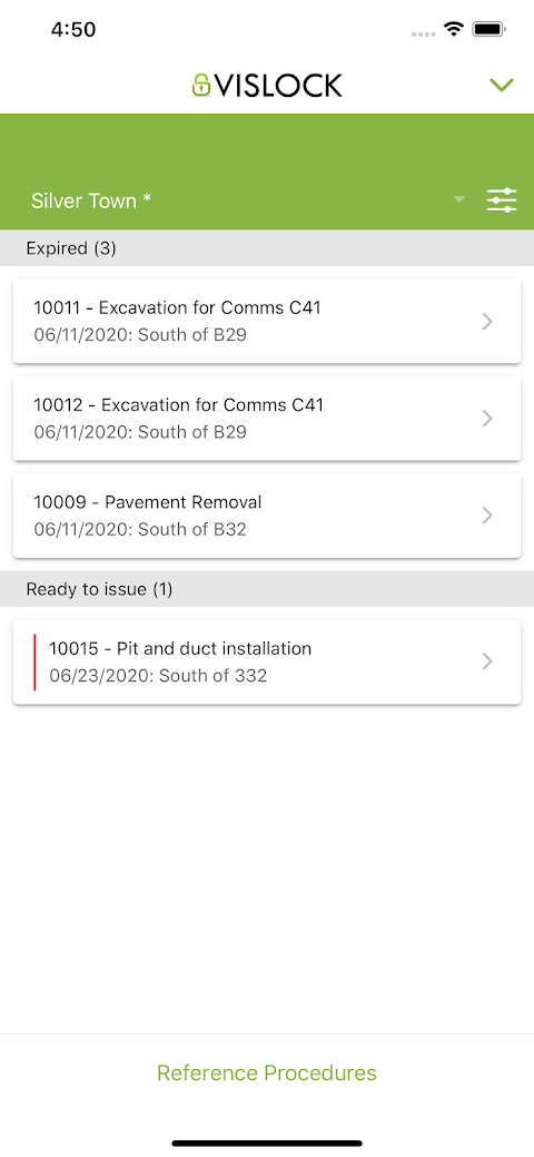
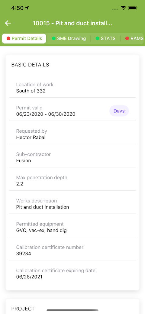
Digital permit to dig
Submit, review and approve permits online with no paperwork or delays. Built-in safety checks prevent a permit being issued until controls are complete.
Esri ArcGIS & GIS boundaries
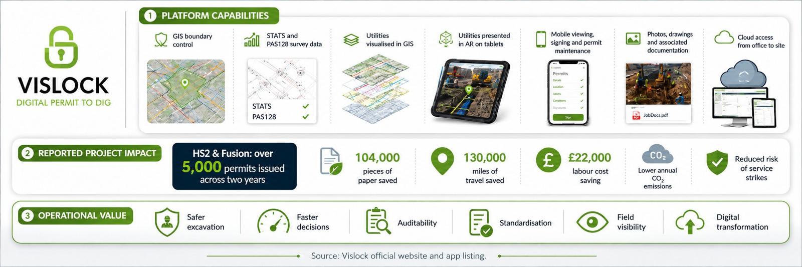
On Vislock Civils, Esri ArcGIS is built into the workflow: manage STATS and PAS 128 survey data and dig boundaries on a live map, and overlay drone-survey photogrammetry on existing utilities. Vislock Lite uses layered static CAD overlays instead.
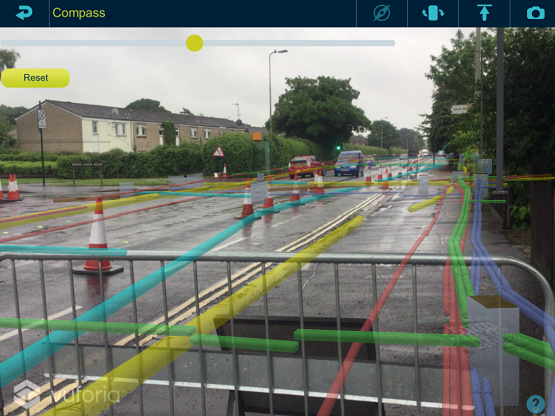
Utilities in GIS & AR
Present many types of survey data on tablets, including GIS and Augmented Reality, so assets can be interpreted easily on site.
Safer worksites
Ensures all known underground services are located with photo validation and approved before digging, with GPS validation that permits are issued at the place of work.
Full visibility & control
Live dashboards show every active and closed permit in real time, with instant access to drawings, survey data and permit history from any device.
Proven compliance
Fully aligned with HSG47, CDM and client safety standards, providing a complete audit trail for assurance and reporting.
How it works
From survey to safe dig
A simple but smart workflow that locks down the permit to dig process with clear roles and responsibilities.
01
Load your survey data
Import STATS and PAS 128 survey data and set your dig boundaries on the GIS map as one source of truth.
02
Raise a digital permit
Site engineers request a permit to dig against the mapped excavation zone and submit approved RAMS, no paperwork required.
03
Review & approve
The permit team reviews supplied documentation, marks known services on site and approves the permit from any device.
04
Dig safely, fully recorded
Work proceeds with daily checks and a complete, time-stamped record kept automatically through to permit closeout and as-builts.
Roles & responsibilities
Who is responsible for the permit to dig process?
When you partner with Vislock, a dedicated team oversees the process from start to finish. Each role has clear responsibilities and defined permissions in the system.
01
Client
Associated with the Project Manager
Oversees the project procedure and workflow setup with viewing rights — and the ability to STOP a permit at any stage.
02
Permit Manager
Associated with the Service Coordinator
Ensures STATS and PAS 128 surveys are complete on the service drawing, maintains a single source-of-truth model (GIS / CAD / BIM), sets up the system, manages documentation approval and owns the dashboard and permit log — closing each permit once as-builts are received.
System approval required
03
Permit Requester
Associated with Site Engineers
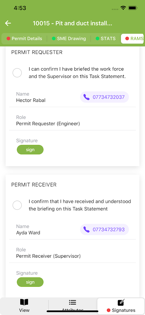
Requests a permit, submits approved RAMS and briefs the work gang on them.
System approval required
04
Permit Issuer
Associated with a Service Locator
Reviews the documentation, marks and photographs all known services on site before work starts, briefs the team on services and exclusion zones, and maintains service markings for the life of the permit.
System approval required
05
Permit Receiver
Associated with the Immediate Supervisor
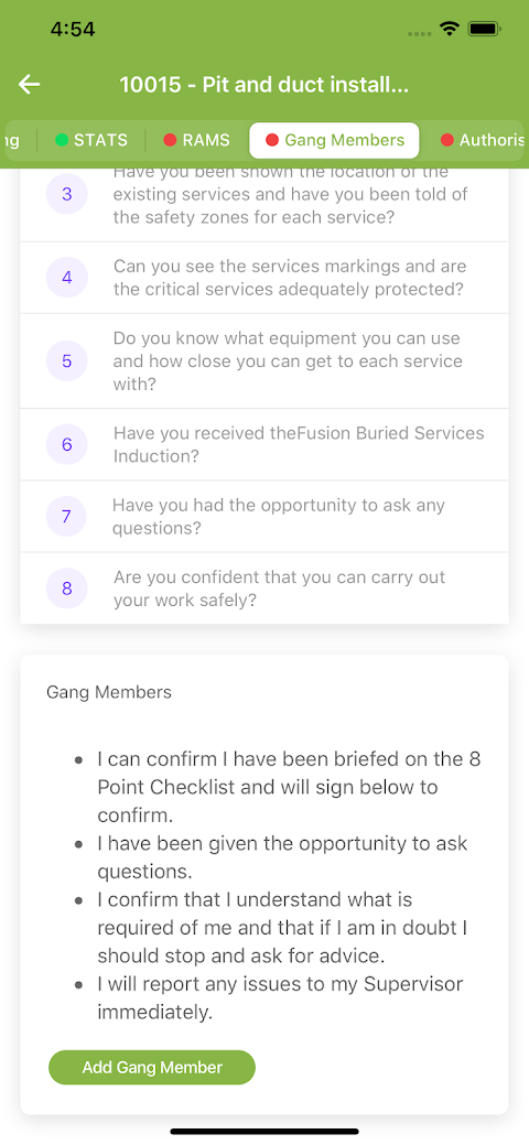
Receives the RAMS briefing from the Permit Requester and the services briefing from the Permit Issuer, then updates an 8-point checklist every day.
System approval required
06
As-Builts
Associated with the CAD Coordinator & Site Engineer
Records as-built information on site and issues updates to the services drawing — ready for the next permit and to close out the current one.
See it in action
Watch Vislock in action
See the digital permit to dig platform, GIS survey data and the on-site
workflow in the Vislock team's own walkthroughs.
View, sign and maintain permit documentation and drawings on a tablet
on site — once they've been submitted from the office on the web
platform. The same locked-down process, with full transparency over
roles and responsibilities, in your hand.
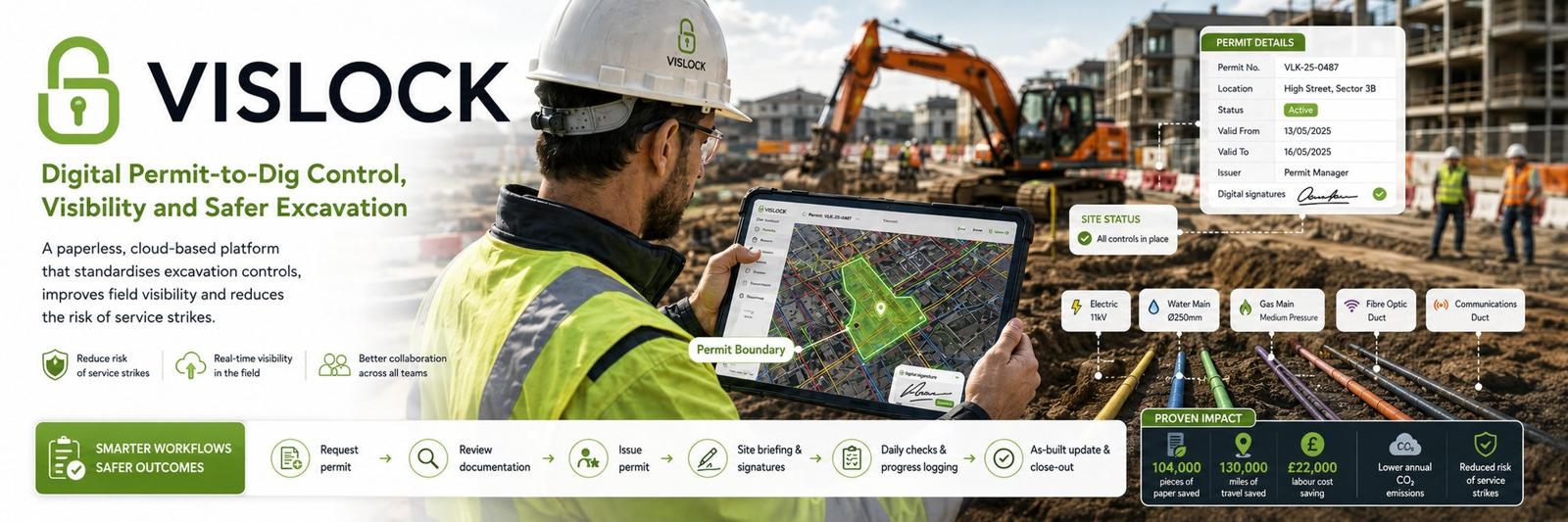
Over the last two years, Vislock has supported HS2 & Fusion in issuing over 5,000 permits. The figures below show the saving to the project.
5,000+
Permits issued over two years
104,000
Sheets of paper saved
130,000
Miles of travel saved
£22,000
Saved in labour costs
What people say about Vislock
Infrastructure and utilities teams use Vislock to keep their crews safe and their projects moving.
Vislock is revolutionary within the industry. In 20 years of working with permit to dig, I have come across nothing similar to Vislock.
Dan Stanton
Service Locator & Utilities Coordinator, Vision
Vision Survey
Frequently asked questions
What is a permit to dig?
A permit to dig is a formal management system used to control the high risks of excavation work. It is a document that specifies the work to be done and the precautions to be taken, forming an essential part of a safe system of work — issued before any groundbreaking work begins. Everyone involved is made aware of service locations and signs the permit to confirm they understand the controls. Vislock is the paperless, automated version of that process.
How does Vislock help reduce service strikes?
Just one step missed in a paper process can result in high-risk damage on site. Vislock gives every key role set responsibilities and constantly monitors the process, and it requires known services to be located, marked and photographed before work starts — reducing the chance of a service strike.
Can the team use it on site?
Yes. The permit to dig is presented on site-based tablets for the permit issuers, so the responsible person can brief and approve elements of the process. The tablet stays with the excavator at the time of permit approval.
Does it integrate with our survey data?
Vislock Civils is built around GIS and Esri ArcGIS, and can present STATS information and PAS 128 survey data — with utilities shown in GIS and Augmented Reality, and drone-survey photogrammetry overlaid on existing services. Vislock Lite supports layered static CAD overlays instead of live GIS.
Is there an audit trail?
Every permit, approval and amendment is time-stamped and stored, giving you full traceability for compliance and project records, aligned with HSG47 and CDM.
Ready to start digitising your permit to dig process?
The no-obligation demonstration only takes an hour of your time and lets you explore the platform and its key features. A team member will arrange a visit, in person or online.


 For large civil engineering contractors